Whitehorse, Yukon
| City of Whitehorse, Yukon Ville de Whitehorse, Yukon |
|||
|---|---|---|---|
 |
|||
|
|||
| Motto: Our People, Our Strength (English) Nos personnes, Notre force (French) |
|||
 |
|||
| Coordinates: | |||
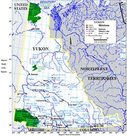
| Country | |||
| Territory | |||
| Established | 1898 | ||
| Government | |||
| - City Mayor | Bev Buckway | ||
| - Governing body | Whitehorse City Council | ||
| - MPs | Larry Bagnell | ||
| - MLAs | Todd Hardy Elaine Taylor Arthur Mitchell Glenn Hart Don Inverarity Archie Lang Jim Kenyon Ted Staffen John Edzerza |
||
| Area | |||
| - City | 416.43 km2 (160.8 sq mi) | ||
| - Metro | 8,488.48 km2 (3,277.4 sq mi) | ||
| Elevation | 670–1,702 m (2,200–5,584 ft) | ||
| Population (2006) | |||
| - City | 20,461 | ||
| - Density | 49.1/km2 (118.6/sq mi) | ||
| - Metro | 22,898 | ||
| - Metro density | 2.7/km2 (7/sq mi) | ||
| Time zone | Pacific (PST) (UTC-8) | ||
| - Summer (DST) | PDT (UTC-7) | ||
| NTS Map | 105D11 | ||
| GNBC Code | KABPC | ||
| Website | City of Whitehorse | ||


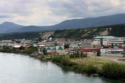
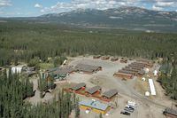
Whitehorse (pronounced /ˈhwaɪt.hɔrs/) (2006 population 20,461; CA population 22,898) (known as White Horse until March 21, 1957)[1] is the capital of the Yukon, Canada. Whitehorse accounts for almost 3/4 of the territory's population and is the largest city in the three Canadian territories. Whitehorse is also famous for natural parks and landscapes, receiving the National Civic Lead award for its natural beauty.
Contents |
Geography
Whitehorse is located at Historic Mile 918 (current kilometre post calibration is kilometre 1,425.3) of the Alaska Highway and is the former terminus of the White Pass and Yukon Route Railway from Skagway, Alaska (although the railway tracks still exist, the train only runs as a tourist attraction from Skagway to Carcross, south of Whitehorse). At the head of navigation on the Yukon River, the city was an important supply and centre during the Klondike Gold Rush. It has been the territorial capital since 1953,[2] when the seat was moved from Dawson City after the construction of the Klondike Highway. Whitehorse is in the mountain climate region, the tundra soil region, the Arctic vegetation region, and the boreal cordillera ecozone. The city gets its name from the White Horse Rapids, which were said to look like the mane of a white horse. Alternate stories have the rapids named after a First Nations Chief who drowned while crossing the rapids. The rapids have disappeared under Schwatka Lake, formed by the construction of a hydroelectric dam in 1958.
Neighbourhoods
In addition to the central Whitehorse City Centre area, the city also includes the smaller neighbourhoods of Porter Creek, Riverdale, Granger, Crestview, Cowley Creek, Marsh Lake, Copper Ridge, Valleyview, Hillcrest, Lobird and Takhini and the Kwanlin Dun First Nation settlement (locally known as "The Village").
Climate
Like most of the Yukon, Whitehorse has a dry subarctic climate. Whitehorse experiences an annual temperature average with daily highs of 21 °C (69.8 °F) in July and average daily lows of −22 °C (−7.6 °F) in January. The record high temperature was 34 °C (93.2 °F) in June 1969 and the lowest was −52 °C (−61.6 °F) in January 1947. Whitehorse has little precipitation with an average annual snowfall of 145 cm (57.09 in) and 163 mm (6.4 in) of rainfall.
According to Meteorological Service of Canada, Whitehorse has the distinction of being Canada's driest city, mainly because it lies in the rain shadow of the Coast Mountains.[3] Surprisingly, despite its relative cold, Whitehorse was ranked among Canadian cities with the most comfortable climate.[4]
| Climate data for Whitehorse | |||||||||||||
|---|---|---|---|---|---|---|---|---|---|---|---|---|---|
| Month | Jan | Feb | Mar | Apr | May | Jun | Jul | Aug | Sep | Oct | Nov | Dec | Year |
| Record high °C (°F) | 9 (48) |
11.7 (53.1) |
11.7 (53.1) |
20.6 (69.1) |
34.1 (93.4) |
34.4 (93.9) |
32.8 (91) |
31.6 (88.9) |
26.7 (80.1) |
18.9 (66) |
11.7 (53.1) |
9.5 (49.1) |
34.4 (93.9) |
| Average high °C (°F) | -13.3 (8.1) |
-8.6 (16.5) |
-0.8 (30.6) |
6.4 (43.5) |
13.1 (55.6) |
18.5 (65.3) |
20.5 (68.9) |
18.5 (65.3) |
12.2 (54) |
4.3 (39.7) |
-5.8 (21.6) |
-10.6 (12.9) |
4.5 (40.1) |
| Daily mean °C (°F) | −17.7 (0.1) |
−13.7 (7.3) |
-6.6 (20.1) |
0.9 (33.6) |
6.9 (44.4) |
11.8 (53.2) |
14.1 (57.4) |
12.5 (54.5) |
7.1 (44.8) |
0.6 (33.1) |
-9.4 (15.1) |
−14.9 (5.2) |
-0.7 (30.7) |
| Average low °C (°F) | -22.0 (-7.6) |
-18.7 (-1.7) |
-12.3 (9.9) |
-4.6 (23.7) |
0.7 (33.3) |
5.1 (41.2) |
7.7 (45.9) |
6.3 (43.3) |
2.0 (35.6) |
-3.1 (26.4) |
-13.0 (8.6) |
-19.1 (-2.4) |
-5.9 (21.4) |
| Record low °C (°F) | -52.2 (-62) |
-51.2 (-60.2) |
-40.6 (-41.1) |
-29.4 (-20.9) |
-11.7 (10.9) |
-2.8 (27) |
-0.5 (31.1) |
-4.4 (24.1) |
-19.4 (-2.9) |
-31.1 (-24) |
-40.6 (-41.1) |
-47.8 (-54) |
-52.2 (-62) |
| Precipitation mm (inches) | 16.7 (0.657) |
11.4 (0.449) |
10.4 (0.409) |
7.0 (0.276) |
15.2 (0.598) |
30.3 (1.193) |
41.4 (1.63) |
39.4 (1.551) |
34.1 (1.343) |
23.8 (0.937) |
19.2 (0.756) |
18.5 (0.728) |
267.4 (10.528) |
| Rainfall mm (inches) | 0.2 (0.008) |
0.1 (0.004) |
0 (0) |
1.3 (0.051) |
13.0 (0.512) |
29.7 (1.169) |
41.4 (1.63) |
38.5 (1.516) |
29.3 (1.154) |
8.8 (0.346) |
0.7 (0.028) |
0.3 (0.012) |
163.1 (6.421) |
| Snowfall cm (inches) | 23.7 (9.33) |
16.8 (6.61) |
14.9 (5.87) |
8.0 (3.15) |
2.4 (0.94) |
0.5 (0.2) |
0 (0) |
1.0 (0.39) |
5.1 (2.01) |
18.9 (7.44) |
27.3 (10.75) |
26.4 (10.39) |
145.0 (57.09) |
| Avg. precipitation days | 11.0 | 8.6 | 7.2 | 5.1 | 7.4 | 10.6 | 13.4 | 12.6 | 11.8 | 11.5 | 11.3 | 11.7 | 122.2 |
| Avg. rainy days | .19 | .15 | .07 | 1.2 | 6.9 | 10.6 | 13.4 | 12.5 | 10.8 | 5.1 | .61 | .21 | 61.73 |
| Avg. snowy days | 12.0 | 9.7 | 7.7 | 4.6 | 1.2 | .11 | 0 | .39 | 1.7 | 8.2 | 12.6 | 12.9 | 71.1 |
| Sunshine hours | 46.7 | 104.9 | 161.2 | 235.1 | 261.5 | 269.4 | 249.9 | 232.0 | 135.7 | 88.5 | 43.2 | 27.0 | 1,855.1 |
| Source: Environment Canada | |||||||||||||
Infrastructure
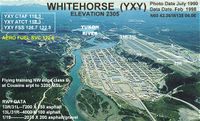
Whitehorse is served by the Erik Nielsen Whitehorse International Airport and has scheduled service to Vancouver, Calgary, Edmonton, Fort Simpson, Yellowknife as well as Fairbanks, Alaska and Frankfurt, Germany during the summer months. The airport was developed as part of the Northwest Staging Route in 1941-42 and has two long paved runways. A wartime-era hangar served as terminal building from about 1960, and was replaced in December 1985 with a modern terminal; expansion of the terminal is to be completed in 2010.
Surface access to Whitehorse is provided by a network of highways, including the international Alaska Highway connecting the Yukon with the Alaska, British Columbia, and Alberta highway networks.
The Yukon River is essentially navigable, but no passenger or freight services use the river at Whitehorse. Whitehorse has a number of taxi companies, as well as the city-owned Whitehorse Transit, which provides bus service on weekdays and Saturdays from morning until early evening. There is a waterfront tram, known as the "trolley", which provides transport along a short rail section along the Yukon River; it is chiefly tourist-oriented and is not yet integrated into the municipal transit system. It runs from the Rotary Peace Park, located on the south end of the city centre, up to the north end of the city centre at Spook Creek Station.
Whitehorse has been described as "pearls on a string", with its residential, industrial, and service subdivisions located along the main thoroughfares that carry traffic within city limits, with large gaps of undeveloped (often hilly) land between them. The Alaska Highway is the primary roadway, with branch roads reaching additional subdivisions. One such branch road, signed as "Highway 1A" and following Two Mile Hill Road, 4th Avenue, 2nd Avenue, and Robert Service Way, is the main access to downtown, Riverdale, and the Marwell Industrial Area. Other branch roads (Range Road, Hamilton Boulevard, Mayo Road) access smaller residential areas and recreational facilities. Whitehorse presently has no active railway service. The city is reached by the tracks of the White Pass and Yukon Route, of which only a small portion are currently maintained to run a small trolley service in the summer. The last scheduled service to Whitehorse occurred in October 1982. The White Pass Railway started scheduled service from Skagway, Alaska to Carcross, 72 kilometers (45 miles) south of Whitehorse, in the spring of 2007, but this was disrupted by high lake water levels in August 2007. Speculation of a trans-continental rail link to Alaska includes one possible route option through Whitehorse; a report has recommended a hub at Carmacks, with a spur line to Whitehorse and on to the Inside Passage of Alaska.
The city road network is adequate, although it is congested during rush hours and discussions occasionally occur as to how it might better be managed, such as designating one-way streets. There are some bottlenecks, such as the single two-lane bridge to the Riverdale subdivision. Street surfaces are in fairly good condition.
Education
Whitehorse has several schools as part of a Yukon-government operated public school system, and it is the home of the main campus of Yukon College.[5]
High schools:
- Vanier Catholic Secondary (Catholic)
- FH Collins Secondary (offers programs for English and French Immersion)
- Porter Creek Secondary
Elementary schools (K-7):
- Christ the King Elementary (Catholic)
- Holy Family Elementary (Catholic)
- Elijah Smith Elementary
- Golden Horn Elementary
- Hidden Valley Elementary
- Jack Hulland Elementary
- Selkirk Elementary
- Takhini Elementary
- Whitehorse Elementary (French Immersion)
Primary school (K-3):
French First Language school (K-12):
Specialized programs:
- Wood St. School (programs are attended by students drawn from the high schools)
- Individual Learning Centre (for students who have had trouble in the regular school program, and are not attending school)
Outside of the one French First Language school, the territory does not have school boards; they do, however, have school councils for each school, composed of elected citizens (including parents of students in the school) and the administrators of the school. All teachers work directly, as Yukon Territorial employees, for the Department of Education.
Whitehorse also has Yukon College, a post-secondary institution with ties to the University of Northern British Columbia.
Whitehorse schools do not close for anything other than holidays. For example, unlike most school districts in more temperate climates, snow days are never called for snow (or other weather phenomena).
Culture
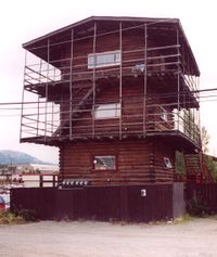
Some of the tourist attractions in Whitehorse are Miles Canyon, the SS Klondike sternwheeler, the Yukon Transportation Museum, the MacBride Museum, the Whitehorse trolley, the Old Log Church Museum,[6] the Beringia Centre, Yukon Gardens, "Log Skyscrapers", the Whitehorse fish ladder, the Yukon Wildlife Preserve, the Takhini Hot Springs, and the Yukon visitor centre.
Sports and recreation
Whitehorse's proximity to the wilderness and the Northern range of the Rockies allows its residents to enjoy a very active lifestyle. The city has hosted several large sporting events including the 2007 Canada Winter Games,[7] the Canadian Junior Freestyle Championships in 2006, the Arctic Winter Games[8] (2000, 1992, 1986, 1980, 1972).
A CA$45 million multiplex centre was built for the Canada Winter Games in 2007. Whitehorse also previously hosted the 1972, 1980, 1986, 1992 and 2000 Arctic Winter Games.
The city has an extensive trail network within its limits, estimated at 850 km (528 mi) in 2007,[9] including sections of the Trans Canada Trail. These trails are used for a variety of non-motorized and motorized activities.
Whitehorse is also home to the Yukon Quest, an international 1,000 mile sled dog race that is considered one of the toughest in the world. In 2010, the Yukon Quest will end in Whitehorse. The race alternates its starting and finishing points each year between Fairbanks, Alaska and Whitehorse, Yukon.
Recreational facilities
Whitehorse enjoys many recreational facilities.
The newest is the Canada Games Centre which houses:
- Whitehorse Lion's Aquatic Centre (25 m pool, diving board, hot tub, sauna, waterslide, lazy river, and a family pool)
- Three skating rinks (NorthwesTel Arena, Olympic Arena, Leisure Ice)
- Fieldhouse (artificial turf)
- Flexi-Hall (sprung hardwood floor)
- Wellness Centre (weights and cardio)
- Indoor Walking/Running Track
- Child Play Area
- Party and Meeting Rooms
- Physio Plus
- Two food services (coffee and sandwiches)
Other facilities include:
- Takhini Arena skating rink
- One seasonal outdoor rinks in each neighborhood
- Two golf courses (Meadow Lakes Golf and Country Club, Mountain View Golf Course, and Wolf Creek under construction)
- Better Bodies Cross Training Centre, home of Squash Yukon
- Mount Sima, 350 m, operates 12 downhill runs from mid-December to April (two lifts, one lodge)
- "Mount McIntyre Recreation Centre", home of the Whitehorse Cross Country Ski Club
- Four outdoor tennis courts located at the Mount McIntyre Recreation Centre.
Sports teams
Although there are no territorial junior league teams, the business community sponsors a number of local teams of baseball, basketball, broomball, hockey, soccer and Ultimate. High school teams are very active and partake in competitions with schools in neighboring Alaska, and a few local athletes have flourished on the Canadian sports scene. There is also a synchronized swimming team called the Northern Novas.
Military
Located just outside of downtown Whitehorse, Whitehorse Cadet Summer Training Centre (WCSTC) offers a variety of cadet based courses and activities throughout the summer. Most of these courses last 6 weeks and are mainly leadership and adventure oriented.
Historically, Whitehorse also was the location of units of the Canadian Army and the Royal Canadian Air Force; the Canadian Army was the last to pull out in 1968, at the same time the armed forces were unified.
Media
Internet service, including broadband service, is available from a number of local providers, including the cable television and telephone companies. Internet rates are exceptionally costly, while the quality of service remains low. The local telephone service provider is Northwestel.
- Television
Whitehorse has two local television stations, one being an ad channel and the other a community posting board, both in slideshow style format with radio in the background; also, the regional Yukon bureau of the Canadian Broadcasting Corporation contributes daily to the regional pan-northern newscast that originates in Yellowknife. CBC television established a TV transmitter in Whitehorse in 1968, using the Frontier Coverage Package until Anik satellite broadcasts became available early in 1973. In addition, some local TV programs are produced for APTN.
- Channel 4 - CKWH
- Channel 6 - CFWH-TV, CBC-North
- Channel 7 - CBFT-15[10], Radio-Canada
- Channel 11 - CHWT-TV, APTN
Whitehorse is served by a cable television company: WHTV (Northern Television Systems Ltd.), founded in 1958, but purchased by Northwestel as of 1 September 2007, carries 71 analog channels plus a digital service; Northwestel will invest and upgrade the system for HDTV late in 2007. WHTV was then renamed to "Northwestel Cable Inc." As with all of Canada, direct satellite TV is available from Canada's two competing providers, Shaw Direct and Bell TV.
- Radio
- AM 570 - CFWH, CBC Radio One
- AM 610 - CKRW, hot adult contemporary
- FM 92.5 - CJUC. community radio
- FM 93.5 - CHLA, tourist information/weather (defunct)
- FM 96.1 - CKRW, hot adult contemporary
- FM 98.1 - CHON, First Nations community
- FM 100.3 - VF2356, tourist information
- FM 100.7 - CIAY, Christian radio
- FM 102.1 - CFWY, Première Chaîne
- FM 104.5 - CBU-FM-8, CBC Radio 2
(CKRW simulcasts on both AM and FM transmitters.)
Whitehorse has two newspapers. The Whitehorse Star, founded in 1900, progressed from a weekly to twice-weekly, three-times weekly during the 1960s and mid-1980s, ran five times per week briefly around 1980–1983, and has been published five times per week since about 1986. The Yukon News, founded in 1960 by Ken Shortt, was a weekly until 1967 when it was published five times per week for several years, and currently prints three times a week. Whitehorse also has periodicals for local special interests, such as L'Aurore boréale for the francophone community, and What's Up Yukon.
Demographics
| Census | Population |
|---|---|
| 1941 | 754 |
| 1951 | 2,594 |
| 1961 | 5,031 |
| 1971 | 11,217 |
| 1981 | 14,814 |
| 1991 | 17,925 |
| 2001 | 19,058 |
| 2006 | 20,461 |
According to the Canada 2006 Census:[11]
| Population: | 20,461 (+7.4% from 2001) |
| Land area: | 416.43 km2 (160.78 sq mi) |
| Population density: | 49.1 inhabitants per square kilometre (127 /sq mi) |
| National population rank: | Ranked 186th out of 5,008 |
| Median age: | 35.1 (males: 34.8, females: 35.3) |
| Total private dwellings: | 8,631 |
| Dwellings occupied by permanent residents: | 8,280 |
| Median household income: | $60,139 |
Notable residents
- Tahmoh Penikett, actor on Battlestar Galactica and Dollhouse.
- Carl Barks, creator of Scrooge McDuck, frequent visitor to Whitehorse while mining for gold
- Pierre Berton, author, born in Whitehorse
- Bryon Baltimore, professional hockey player
- Zachary Bell, Olympian, born in Whitehorse
- Ione Christensen, politician
- Jeane Lassen, is a 2008 Olympian
- Paul Lucier, the first Senator for the Yukon, appointed 1975
- Audrey McLaughlin, politician
- Aaron Olson, Olympian, born in Whitehorse
- Robert W. Service, poet
- Amy Sloan, actress
- Jonas Smith, punk rock bassist for JJS3[12]
- Peter Sturgeon, professional hockey player
- Greg Wiltjer, Olympian, born in Whitehorse.[13]
See also
- Bob Smart's Dream, a 1906 poem by Robert Service that speculates about the Whitehorse of the future.
- This Dollar Saved My Life at Whitehorse, a 2001 album by Lucyfire
References
- ↑ Robert G. Woodall, The Postal History of Yukon, Canada, Lawrence, MA, Quarterman, Revised edition, ©1976, ISBN0-88000-086-4, p.239
- ↑ "The Whitehorse Interactive Traveller's Guide". pp. History->Facts->Whitehorse->The Name "Whitehorse". http://www.visitwhitehorse.com/. Retrieved 2006-07-03.
- ↑ Weather Winners WebSite
- ↑ Weather Winners WebSite
- ↑ Yukon Education Student Network - Schools
- ↑ The Canadian Encyclopedia
- ↑ Canada Games - Winter 2007
- ↑ "Arctic Winter Games 2008". http://www.awg2008.ca
- ↑ City of Whitehorse 2007 Trail Plan
- ↑ Sign-off clip for CBUFT on YouTube
- ↑ "2006 Community Profiles". Statistics Canada. Government of Canada. 2009-02-24. http://www12.statcan.ca/census-recensement/2006/dp-pd/prof/92-591/index.cfm?Lang=E. Retrieved 9 March 2009.
- ↑ A one-man band’s long journey
- ↑ Sports-Reference
External links
- City of Whitehorse
- Yukon Government Fact Page
- Community Profile
- Whitehorse, Yukon at the Open Directory Project
 |
Ibex Valley | Pelly Crossing | Ross River Faro |
|
| Kluane National Park and Reserve | ||||
| Fish Lake | Mount Lorne Carcross |
Tagish |
|
|||||||||||||||||
|
|||||